


portes de Montmelian

franquen
User
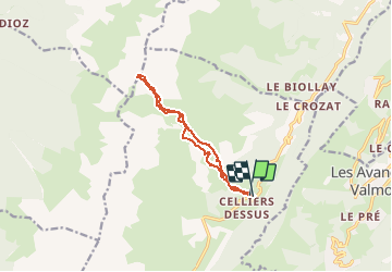

Length
11.2 km

Max alt
2426 m

Uphill gradient
1043 m
Km-Effort
25 km

Min alt
1356 m

Downhill gradient
1053 m
Boucle
Yes
Creation date :
2020-03-08 07:27:58.627
Updated on :
2020-03-08 12:11:29.415
4h41
Difficulty : Very easy

FREE GPS app for hiking
 SityTrail
IGN / Geographical institutes
SityTrail Plus
The world is yours!
About
Trail Touring skiing of 11.2 km to be discovered at Auvergne-Rhône-Alpes, Savoy, La Léchère. This trail is proposed by franquen.
Positioning
Country:
France
Region :
Auvergne-Rhône-Alpes
Department/Province :
Savoy
Municipality :
La Léchère
Location:
Celliers
Start:(Dec)
Start:(UTM)
297951 ; 5038992 (32T) N.
Comments